
Walking the Old Edge of Bangkok: Khlong Rop Krung Canal
Bangkok’s old royal quarter is still ringed by water. Khlong Rop Krung, whose name translates as “the canal around the city”, curves for several kilometres from the Chao Phraya near Bang Lamphu to rejoin the river further south, tracing the eastern edge of the old royal city. Most visitors cross it without noticing, on their way between the Grand Palace and Khao San Road. Yet for much of Bangkok’s history this was a boundary, a defence and a busy waterway, and its banks still hold traces of the communities that grew up along it.
From Moat to Market
The canal dates back to 1783, when King Rama I moved the capital from Thonburi to the east bank of the Chao Phraya. It was dug as a moat to guard the new royal city’s eastern flank, with the river protecting the west, and the two together turned the old centre into what is still called Rattanakosin Island. As the city grew beyond its walls, the canal took on a second life as a working waterway. Boats carried goods between the river and the neighbourhoods along its banks, and its southern stretch, Khlong Ong Ang, became a trading point for pottery sold by the Mon and Chinese communities who lived there.
As Bangkok spread east and roads replaced boats as the main way of getting around, the canal lost much of its everyday purpose. Its water grew polluted, and along its southern stretch it all but disappeared from view. From the 1980s, the Saphan Lek market spread across Khlong Ong Ang on makeshift platforms built over the water, a maze of stalls selling toys, electronics and, according to frequent police raids, a good deal of counterfeit goods. For around three decades, this part of the canal could barely be seen at all.
A Contested Revival
That changed in October 2015, when the city demolished the market to reclaim the canal. The cleared banks then sat largely unused for several years before the Khlong Ong Ang Walking Street opened in 2020, along the cleaned-up stretch between the Saphan Han and Damrong Sathit bridges.
Not everyone shares in the revival. The stalls had been cramped and unsafe, but they had also been part of the neighbourhood for decades, and 48 vendors took the city to court in an attempt to stop the demolition. It went ahead regardless. Many of the traders moved into Mega Plaza Saphan Lek, a mall near the old bridge, where the shops now sell much the same goods as before. For the families whose businesses had sat over the water for three decades, the restored canal marks what they lost as much as what the city gained.
How to judge the revival depends on who you ask. To the city, Khlong Ong Ang is a model: a polluted, built-over canal turned into public space. To its critics, it is a case of a working market being cleared to make way for something tidier and more tourist-friendly. Both readings are fair, and the canal holds both histories.
On Foot and by Water
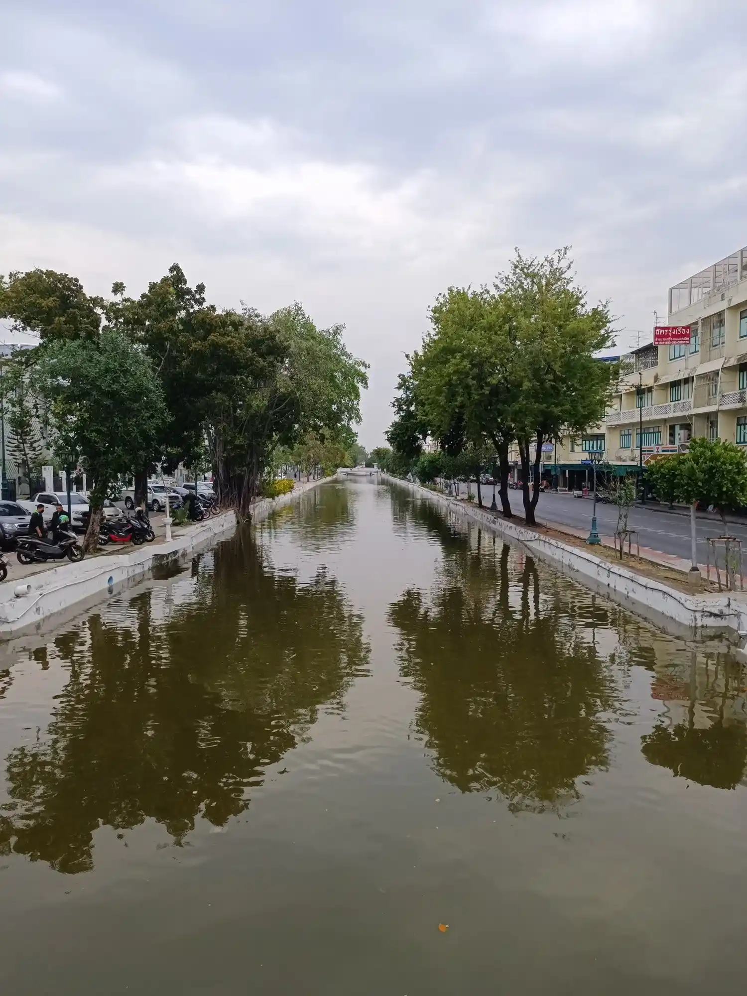
Walking the canal today, you see its history more clearly in some stretches than others. Along Khlong Ong Ang, the restoration has cleared the water and lined both banks with paths, planters and benches, while murals on the walls depict daily life in the Thai, Chinese and Indian communities the canal passes through. Elsewhere it is plainer: a walled channel shaded by trees, with shophouses, parked motorbikes and traffic alongside, much as it appears in the photograph above.
On weekend evenings, vendors set up along both banks of the Ong Ang stretch and buskers play by the water. Most of what’s on offer is food: rice and roti dishes, grilled squid, meatballs and Thai sweets, eaten standing up or on the low walls by the canal. The rest of the week, and along most of the canal’s length, there are no stalls at all, just the ordinary traffic of a working neighbourhood.
The best way to see the canal is from the water. Kayaks and stand-up paddleboards can be rented along the Ong Ang stretch, and from the canal itself the shophouses, bridges and temple walls line up in a way you don’t notice from the street. For a longer view, the Khlong Saen Saep express boats run from Phan Fa Lilat pier, near the canal’s northern section, east into the newer city, giving a sense of how these waterways once connected Bangkok together.
The canal is not quite an escape from the city, and it doesn’t need to be. Traffic runs alongside it for most of its length, and the Ong Ang stretch is rarely quiet at weekends. But it offers something rarer in Bangkok: a way to read the shape of the old city on foot. Start at Phra Sumen Fort in Bang Lamphu, near where the canal leaves the river, and follow it south. You are walking the edge of the capital Rama I laid out in 1783, a line that still holds after more than two centuries of change around it.
Hanan: text, video, photo31 January 2024, updated 8 October 2026
You Might Like This
Loved this one? We picked a few more you might like.

Your voice!
Wow, this canal seems like such a peaceful escape from Bangkok’s chaos. How do locals feel about tourists visiting such a culturally important place?
Definitely, Khlong Rop Krung offers such a serene break from the usual hustle and bustle of Bangkok. As for how locals feel, it’s a bit mixed—some embrace the chance to share their culture with visitors, while others might prefer to keep the area more local and less touristy. I’d say it’s always best to be respectful of the space and the community. That way, everyone can enjoy the beauty of the place.
Reading this felt like travelling from my couch. The canal’s revival shows how history and culture can still thrive even in a modern cityscape. Inspiring!
Glad you enjoyed it. Khlong Rop Krung truly shows how tradition and modernity can beautifully coexist in Bangkok
Discovering Khlong Rop Krung through this article was fascinating. I love how locals are preserving this historic canal. It’s inspiring to see traditions thrive in such a modern city. Can’t wait to visit and explore its unique charm someday.
Khlong Rop Krung truly reflects Bangkok’s blend of history and modernity. You’ll love exploring its charm when you visit.
Such a cool piece of history right here in Bangkok. Love how locals are restoring its charm. It’s amazing to see this hidden gem brought back to life. What inspired you to write about this place in my country?
Bangkok’s blend of history and hidden treasures is always inspiring. Khlong Rop Krung felt like a story worth sharing.